
Nablus is a Palestinian city in the West Bank that lies about 49 kilometers (30 miles) north of Jerusalem and has a population of 156,906. Nestled between Mount Ebal and Mount Gerizim, it serves as the capital of the Nablus Governorate and is governed by the Palestinian National Authority. Moreover, it is a commercial and cultural hub in the State of Palestine. The city hosts An-Najah National University, one of Palestine’s largest higher education institutions, and the Palestine Stock Exchange.
Table of Contents
History of Nablus
The history of Nablus is long and interesting.

Roman and Byzantine Periods
Nablus’s modern name dates back to the Roman period when Emperor Vespasian named the city Flavia Neapolis in 72 CE. Neapolis, the “new city,” was built on the northern slope of Mount Gerizim, about two kilometers west of Tell Balata. It was identified as the Canaanite town of Shechem, mentioned in several ancient sources, and was inhabited during the Chalcolithic, Bronze, Iron, and Hellenistic ages.
During the Byzantine period, conflict between the city’s Samaritan and newer Christian inhabitants peaked in the Samaritan revolts. These were suppressed by 573 CE, significantly reducing the Samaritan population.
Under Roman rule, major building projects included a Hippodrome, a theatre, and other public buildings, and a Roman temple dedicated to Zeus was erected on Mount Gerizim during Antoninus Pius’s reign. The city was elevated to a Roman colony under Philip the Arab.
Early Muslim and Crusader Periods
Following the Muslim conquest of the Levant in the 7th century, the city was given its present-day Arabic name, Nablus. During the reign of Emperor Zeno in 484 CE, a large octagonal church dedicated to Mary Theotokos was built on Mount Gerizim and fortified by Justinian I in the 6th century.
In the first half of the 7th century, the city was conquered by the Arabs of the Umayyad dynasty and was later known as “Little Damascus” due to its inclusion in the province of Damascus.
After the First Crusade, the Crusaders drafted the laws of the Kingdom of Jerusalem at the Council of Nablus, and the city’s Christian, Samaritan, and Muslim inhabitants prospered. The city subsequently came under the control of the Ayyubids and the Mamluk Sultanate.
Ottoman Period and Modern History
Under the Ottoman Turks, who conquered the city in 1517, Nablus served as the administrative and commercial center for the surrounding area, corresponding to the modern-day northern West Bank. The city’s significance continued under Ottoman rule, with the development of its bustling market, or souq, and the establishment of impressive mosques, Turkish baths, and traditional soap factories.
Captured by British forces during World War I, Nablus was incorporated into Mandatory Palestine in 1922. The 1948 Arab–Israeli War saw the entire West Bank, including Nablus, occupied and annexed by Transjordan. Since the 1967 Arab–Israeli War, however, the West Bank has been occupied by Israel. Since 1995, it has been governed by the Palestinian National Authority (PNA) as part of Area A of the West Bank.
Present-Day Nablus
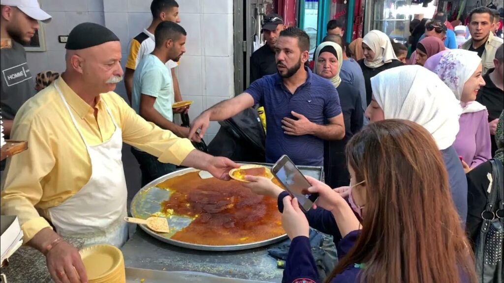
Today, Nablus is the major commercial, industrial, and agricultural center in the northern region of Palestine with a predominantly Muslim population and small Christian and Samaritan minorities. It is known for its olive oil soap, talented goldsmiths, and traditional sweets, and also for being the best place in Palestine to enjoy knafeh. This beloved Palestinian dessert is made from cheese and semolina flour, dripping with sweet rosewater syrup.
Architectural and Cultural Heritage
The seven quarters of the old city represent a distinctive example of traditional urban architecture in Palestine. The city center features a bustling market, or souq, with impressive mosques, Turkish baths, and traditional soap factories. Despite extensive damage caused by a series of earthquakes over the centuries, Nablus has preserved its historical and cultural heritage, and it continues to thrive as a vital center of Palestinian life.
What is There to Visit in Nablus?
Due to its long history, there are many sites worth visiting. We’ll break down the most important ones below.
Tell Balata (Balata Hill)
Tell Balata is identified as the Canaanite town of Shechem, mentioned in several ancient sources from the second and first millennia BC. The site is nestled between the famous hills of Gerizim and Ebal, where the main north-south and east-west routes of Palestine intersect. This strategic position made it a hub of an extensive early road network.
Geographic and Agricultural Significance
Tell Balata rises approximately 20 meters above the 500-meter contour passing through the village of Balata at the lowest point of the valley. It has been dubbed “the uncrowned queen of Palestine” due to its abundant water sources and favorable winter rainfall, which provide agricultural security.
Historical Excavations
Excavations have uncovered significant insights into the site’s history, particularly its role as an urban center during the second urbanization period in Palestine around 2000 BC. Among the most impressive surviving ruins is a fortress temple, likely used for public worship, and other notable ruins include two monumental gates, massive city walls, a governor’s palace with a small private temple, guardrooms, an assembly, living quarters, and a kitchen.
Rehabilitation Efforts
Between 2010 and 2012, Tell Balata was rehabilitated as an archaeological park through a joint project involving the Palestinian Department of Antiquities, the University of Leiden, and UNESCO. This effort aimed to preserve and highlight the historical and cultural significance of the site.
Mount Gerizim
Mount Gerizim, or Jebel at-Tor, is the sacred mountain of the Samaritans and has held this status for thousands of years. The Samaritans, a small Palestinian community of only a few hundred people, believe the temple on the mountaintop was the first temple built by Yosha’ Bin Noun in the Holy Land. The summit to the top is also known for featuring a rock believed by Samaritans to be where Abraham was about to sacrifice his son Isaac. Samaritans regard Mount Gerizim as the site where a blessing was delivered by divine decree, and that is why it is their belief, according to their tradition, that the temple on Mount Gerizim supersedes the rival claim of the Temple of Jerusalem.
Geographic Features
Mount Gerizim consists of three peaks: the main summit, a wide flat western hill, and Tell ar-Ras to the north. The archaeological remains on the main summit include a large acropolis with paved temenos, massive fortifications with casemate walls, chamber gates, and a surrounding residential quarter. This area likely represents the Samaritan town during the Hellenistic period, which was destroyed by John Hyrcanus in 128 BC. During the early Roman period, the main summit appears to have been deserted. However, a temple to Zeus was built in the second century just north of the summit on Tell ar-Ras, overlooking Nablus.
Archaeological Findings
Archaeological excavations have revealed that the temple discovered on the summit existed before the second century BC and was near a considerable settlement area. This area was occupied, though not necessarily continuously, during the Hellenistic, Roman, Byzantine, and Islamic periods.
Historical Developments
In 484 AD, during the reign of Emperor Zeno, a large octagonal church dedicated to Mary Theotokos was constructed on the main summit. This church was converted into a fortress and later reinforced by Justinian. The presence of this church on their sacred mountain insulted the Samaritans and contributed to their revolt in 529 AD, which led to the church being abandoned in the eighth century and the fortress being dismantled in the ninth century. In the sixteenth century, a shrine to the Muslim saint Sheikh Ghanim was built on the east corner of the ruined church.
Contemporary Relevance
Today, Mount Gerizim continues to be the religious center of the Samaritans. Their village, located below the summit, includes a museum. Annually, many visitors come to witness the Samaritans’ ceremonial procession to and around the mountain summit, and this tradition, they believe, is thousands of years old.
Sebastia
Sebastia (Sabastiya) is located approximately ten kilometers northwest of Nablus at the junction of two main historical routes: the northern Nablus-Jenin route and the western route from the Jordan Valley to the Mediterranean coast. The site offers a magnificent view of the surrounding farmland and is one of the oldest continuously inhabited places in Palestine. It remains known by its ancient name, indicating strong cultural continuity.
Historical Importance
Sebastia served as a regional capital during the second Iron Age and became a major urban center during the Hellenistic-Roman period. Christian and Islamic traditions identify the site as the location of John the Baptist’s tomb.
Archaeological Excavations
A series of excavations at Sebastia began with Harvard University between 1908 and 1910. The most recent excavation by the Palestinian Department of Antiquities in 1994 uncovered parts of an Iron Age city, including a royal palace complex and a central courtyard. Overall, among the major discoveries was an ivory collection from the eighth and ninth centuries BC.
Historical Timeline
During Iron Age II, Sebastia flourished as a regional capital. In 722 BC, it was captured by the Assyrians under Sargon II, becoming the center of the Assyrian province in Palestine. During Persian rule, it continued as a provincial capital for central Palestine. In 332 BC, Alexander the Great captured the city and added massive fortifications around the acropolis, including a circular tower.
By 63 BC, Sebastia became part of the province of Syria. During the Roman period, Herod renamed it Sebaste in honor of Augustus. He implemented a large building program, which included city walls, a gate, a colonnaded street with 600 columns, a basilica, a forum, a theatre, a temple for Augustus, a stadium, an aqueduct, and cemeteries. In 299 AD, Severus renamed it Colonia.
Byzantine and Islamic Periods
During the Byzantine period, Sebastia was the seat of a bishop. A church dedicated to Saint John was built on the southern slope of the acropolis. Both a Byzantine church and a Crusader church, dedicated to Saint John, were constructed in the center of the old village. A mosque was also built in honor of Saint John (Nabi Yahyia).
Present-Day Sebastia
The present town of Sebastia, encompassing the archaeological remains, historical town, and cultural landscape, is one of Palestine’s major tourist attractions. Restoration activities have been carried out in the historic core. These include the renovation of the mosque, the shrine of Nabi Yahyia, the Cathedral of John the Baptist, the Roman mausoleum, the olive press, Kayed Palace, and traditional buildings. Additionally, a walking trail has been established to enhance the visitor experience.
Jacob’s Well
Nestled near the eastern foothills of Mount Gerizim, just a short distance from Balata Village, Jacob’s Well holds a significant place in pilgrimage lore, marking the sacred encounter between Christ and the Samaritan woman. Initially, a church was erected above the well, later destroyed, and subsequently rebuilt by the Crusaders. Today, Jacob’s Well resides within the enclosed precincts of the Greek Orthodox monastery, preserving its historical and spiritual significance.
Joseph’s Tomb
Just slightly to the north of Jacob’s Well, one can find the traditional location of Joseph’s tomb. This site is distinguished by an Ottoman-era structure topped with a striking white dome.
Summary
Nablus, derived from the Ancient Greek Neapolis for “New City,” resides in the West Bank, about 49 kilometers north of Jerusalem, boasting a population of 156,906. It serves as the capital of the Nablus Governorate and, thus, thrives as a commercial and cultural nucleus in Palestine. The city is home to An-Najah National University and the Palestine Stock Exchange, under the governance of the Palestinian National Authority (PNA).
Nablus’s history dates back to the Roman period, with Emperor Vespasian renaming it Flavia Neapolis in 72 CE. Conflict characterized its Byzantine era, notably in the Samaritan revolts, and it flourished under Roman rule with significant building projects. Following the Muslim conquest, it became known as Nablus and witnessed architectural and social developments.
Under Ottoman rule, Nablus emerged as a vital administrative and commercial center. British control during World War I led to its incorporation into Mandatory Palestine. Today, it stands as a major commercial hub known for olive oil soap and knafeh, representing a blend of tradition and modernity in Palestinian life. The city’s cultural heritage, including the seven quarters of the old city and significant archaeological sites like Tell Balata, continues to attract visitors, ensuring its relevance in contemporary times.